Skip to Content

Weather

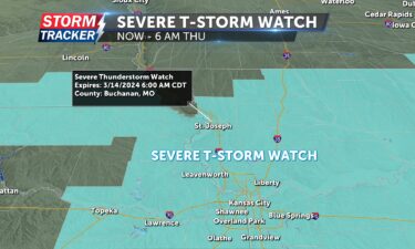
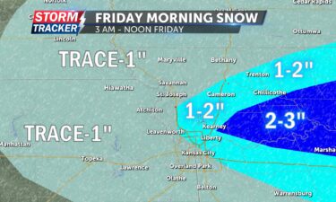
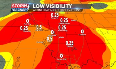
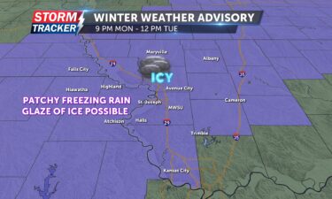
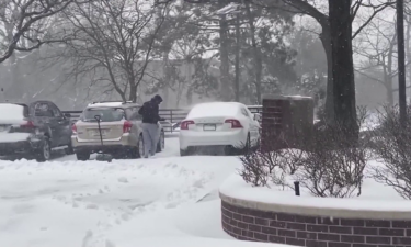
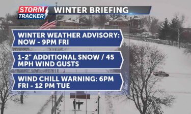
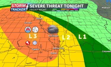
Strong storms possible Friday

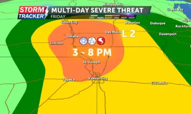
By Meteorologist Jared Shelton Strong to severe thunderstorms are increasingly likely Friday across Northwest Missouri and Northeast Kansas as an early summer storm system tracks across the area. Here’s the latest on what to expect: SEVERE THREAT TONIGHT: ENHANCED RISK TIMING: 9 p.m. Friday to 1 a.m. Saturday THREAT LEVEL: 3 (of 5) HAZARDS: Damaging

Continue Reading

June marks the start of meteorological summer

By Jared Shelton News-Press NOW meteorologist Memorial Day weekend has passed and meteorological summer is fast approaching, marked by the first day of June. While astronomical summer is not officially recognized until the estival solstice (aka summer solstice), occurring in the northern hemisphere between June 20 and 21, sultry summer weather tends to develop across

Continue Reading

Above-average tornado tallies target the heartland

By Jared Shelton News-Press NOW meteorologist Every year is different when it comes to spring severe weather season across the United States. As May comes to a close, stats are revealing that 2024 has been particularly active when it comes to tornadoes. According to the Storm Prediction Center, a preliminary 870 tornadoes have been reported

Continue Reading

Severe weather threat exiting this evening

By Jared Shelton 4:40 p.m. | The tornado watch has been canceled for all of Northwest Missouri and Northeast Kansas, but remains in effect east of interstate 35 through this evening. 2:50 p.m. | A tornado watch has been issued for parts of Northeast Kansas and all of Northwest Missouri until 10 p.m. tonight. This

Continue Reading

Severe weather possible Monday and Tuesday

By Jared Shelton Scattered severe weather will be possible across Northwest Missouri and Northeast Kansas over the next 24 to 48 hours, with a slight risk for gusty winds and small hail developing this afternoon followed by an enhanced risk for damaging winds, sizable hail and tornadoes on Tuesday. Here’s the latest on what to

Continue Reading

Rain causing minor flooding on area rivers

By Jared Shelton A round of thunderstorms late Monday night delivered soaking rains across Northwest Missouri and Northeast Kansas, leaving behind some rising waterways. Rainfall totals ranging from half an inch to three inches across are resulting in minor flooding including on the Platte River near Agency and the Missouri River at St. Joseph. As

Continue Reading

Severe weather threat diminishing overnight

By Jared Shelton 12:30 a.m. | The tornado watch has been canceled for points along and west of the I-35 corridor, including Buchanan County and surrounding areas. 11:27 p.m. | The tornado warning for Clinton County, northwestern Clay County and northeastern Platte County has expired. A tornado watch remains in effect for all of Northwest Missouri

Continue Reading

Scattered severe threat Tuesday

By Jared Shelton 9 p.m. | The tornado watch in effect earlier for parts of Northwest Missouri and Northeast Kansas, including Buchanan County, has been canceled. 6:45 p.m. | A tornado watch remains in effect for parts of Northwest Missouri and Northeast Kansas, including Buchanan County, until 11 p.m. Other counties in the area under

Continue Reading

Tornado watch canceled locally

By Meteorologist Jared Shelton The tornado watch originally scheduled to remain in effect until 9 p.m. tonight has been canceled for points west of interstate 35 including the St. Joseph area. A tornado watch remains in effect for points along and east of interstate 35 until midnight. Heavy rain, gusty winds, and sizable hail will

Continue Reading

Tracking severe weather

By Meteorologist Jared Shelton 8:10 p.m. | The tornado watch has been canceled for Buchanan County and surrounding areas, but remains in effect for parts of far northern Missouri including Nodaway, Worth and Gentry counties through 9 p.m.  6:40 p.m. | The tornado warning has EXPIRED for Nodaway, Holt and Atchison counties.  A tornado watch

Continue Reading

Scattered severe threat developing today

By Meteorologist Jared Shelton A potent spring storm system will be passing through NW Missouri and NE Kansas today, bringing the potential for scattered strong to severe thunderstorms. Here’s the latest on what to expect: HAZARDS: Sizable hail, damaging winds, isolated tornadoes. TIMING: 6 a.m. to 4 p.m. Tuesday THREAT LEVEL: 2 (of 5) The

Continue Reading

Summer-like heat in April?

By Jared Shelton News-Press NOW meteorologist April started off with a bang across Northwest Missouri and Northeast Kansas. The second tornado watch of the season was issued on April 1 amid a rapidly developing severe weather threat, followed up with a half hour of unforecast heavy wet snowflakes the morning of April 2. Neither event

Continue Reading

Diminishing severe weather threat

By Chief Meteorologist Jared Shelton The tornado watch has been canceled for all of Northwest Missouri and Northeast Kansas, and the severe weather threat has diminished.  4:18 p.m.: A tornado watch has been issued for Buchanan County and surrounding areas through 11 p.m. Monday night. 3:10 p.m.: A threat for strong to severe thunderstorms is

Continue Reading

The 1913 Easter tornado outbreak

By Jared Shelton News-Press NOW meteorologist The 2024 spring equinox has passed, and soon another milestone of the season will arrive with Easter. More than a century ago, this holiday marked one of the worst severe weather outbreaks to impact Northwest Missouri, and the Central Plains region as a whole, when six F-4 tornadoes killed

Continue Reading

Mid-March hail strikes St. Joseph area

By Jared Shelton News-Press NOW meteorologist Severe Weather Preparedness Week was recently front and center across Missouri and Kansas, during a time when skies were quiet here in the Central Plains. As if right on queue, this week was quite different, when the first severe weather event of the season materialized on Wednesday evening. Aside

Continue Reading

Developing severe weather threat

By Meteorologist Jared Shelton The previously issued tornado watch has been canceled, and replaced by a severe thunderstorm watch in effect through 6 a.m. Thursday. Heavy rain, gusty winds and hail will continue to be the primary threats through early Thursday morning. Multiple severe thunderstorms are continuing to materialize and move across Northwest Missouri and

Continue Reading
Skip to content