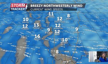
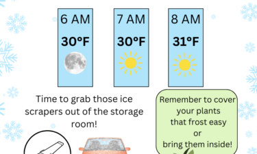
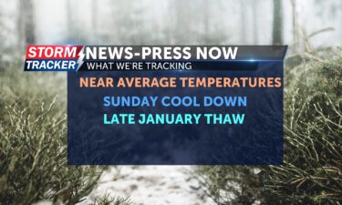
Skip to Content

Weather

Winter storm brings double-digit snowfall

Sunday’s winter storm has finally exited the Mid-Missouri River Valley after producing blizzard conditions and covering the region in a blanket of heavy snow. For the first time since December 2009, St. Joseph and surrounding areas tallied double-digit snowfall totals. The final observations are as follows: Atchison: 15″ St. Joseph: 16″ Cameron: 13″ Savannah: 16″

Continue Reading

Freezing rain could pose travel hazards Friday

By Meteorologist Jared Shelton A Winter Weather Advisory has been issued for much of Northwest Missouri and Northeast Kansas, ahead of the chance for light freezing rain across parts of the area Friday afternoon and evening. Buchanan, Doniphan, Brown, and Atchison counties are under a Winter Weather Advisory from 2 p.m. until 9 p.m. on Friday,

Continue Reading

Storms bring tornado watch for St. Joseph area

By Jared Shelton A tornado watch has been issued for much of Northwest Missouri and Northeast Kansas including Buchanan County and surrounding areas until 10 p.m. Wednesday. A line of severe thunderstorms is moving into Northwest Missouri and Northeast Kansas this afternoon that is capable of producing damaging gusts and sizeable hail. A severe thunderstorm

Continue Reading

Red Flag Warning issued for Thursday, Oct. 17

By Chief Meteorologist Jared Shelton Dry and windy conditions are forecast to produce elevated fire weather concerns across the Mid-Missouri River Valley on Thursday. A Red Flag Warning has been issued for all of Northwest Missouri and Northeast Kansas including Buchanan County, effective from 11 a.m. to 7 p.m. Thursday. Persistent southerly winds of 20

Continue Reading

Prepare for the first freeze in St. Joseph

By Storm Tracker Meteorologist Payton Counts It’s that time of year again! It wouldn’t be autumn without a little frost. The National Weather Service has issued a Freeze Warning for Tuesday night into Wednesday morning. This means there will be frost outside and on your car, so make sure to grab your ice scraper and

Continue Reading

Thursday weather updates

By NewsPress Now A severe thunderstorm warning has been issued for southeastern Buchanan County, southwestern DeKalb County, northwestern Clinton County and northeastern Platte County until 12:30 p.m. More severe weather could be moving throughout the area Thursday. Thunderstorms are especially possible Thursday evening after 5 p.m. Hazards would include damaging winds and large hail. The

Continue Reading

Strong storms possible Wednesday evening

By Meteorologist Jared Shelton 5:34 p.m. | A severe thunderstorm watch has been issued for Buchanan County and much of Northwest Missouri and Northeast Kansas. This is in effect until 1 a.m. Scattered strong to severe thunderstorms are anticipated across Northwest Missouri and Northeast Kansas on Wednesday evening, and into the overnight hours. Here’s the

Continue Reading

Tracking severe weather

By Meteorologist Jared Shelton A Severe Thunderstorm Watch has been issued for all of Northwest Missouri and Northeast Kansas through 3 a.m. Thursday, as scattered strong storms approach the area tonight. The primary hazards with any storms that develop will be damaging straight-line winds and sizable hail. A Severe Thunderstorm Warning is in effect for

Continue Reading

City’s cooling centers offer respite from summer heat

By Ashley Luthans St. Joseph residents have been battling extreme heat recently, but community resources can help provide some relief. After last week’s heat and humidity, heat index values, or “feels-like” temperature, shot up to 112 degrees Fahrenheit on Monday. High temperatures can cause heat-related illness without proper precautions. “Drink plenty of fluids, stay in

Continue Reading

Moderate flooding continues along the Missouri River

By Meteorologist Jared Shelton Water levels on the Missouri River have steadily risen over the past two weeks amid drainage from flooding up-river and locally heavy rainfall. After sustaining moderate flood stage at St. Joseph since Saturday June 29, the Missouri River reached a forecast crest of 23.4 feet on Thursday afternoon, July 4.  Aside

Continue Reading

Strong storms possible Tuesday

By Jared Shelton 5:36 p.m. | A severe thunderstorm warning has been issued for Buchanan County until 6:15 p.m. Scattered strong to severe thunderstorms are possible across Northwest Missouri and Northeast Kansas this afternoon and evening as a low-pressure system tracks across the area. Here’s the latest on what to expect: SEVERE THREAT TODAY: ENHANCED

Continue Reading

Developing severe threat Friday evening

By Chief Meteorologist Jared Shelton 9:15 p.m. | A tornado warning has been issued for Holt, Atchison and Nodaway counties through 9:45 p.m. Southeastern Atchison County, northwestern Holt County and west central Nodaway County are under the warning. The tornado watch is still in effect for all of Northwest Missouri and Northeast Kansas until 11

Continue Reading

Moderate flooding forecast along the Missouri River

By Jared Shelton News-Press NOW Meteorologist Several rounds of heavy rain have swept across parts of the mid and upper Missouri River basin over the past seven to 10 days, resulting in moderate to major flooding of the Missouri River and many of its tributaries north of the I-80 corridor. Drainage from flooding up-river combined

Continue Reading

Heat advisory issued ahead of soaring temperatures

By Meteorologist Jared Shelton High heat and humidity will be building into the mid-Missouri River Valley on Monday afternoon, as a wave of above average temperatures sweeps through the heartland. Temperatures are anticipated to reach the upper 90s to triple digits across Northwest Missouri and Northeast Kansas after lunchtime Monday, with oppressive humidity resulting in

Continue Reading
Skip to content